Geo-referencing in Tunisia everything you'll never learn at school
Positioning errors are
frequent and largely stem from the misconception that providing latitude and
longitude (Lat/Long) coordinates offers complete information. In reality, this
is far from true. These errors also arise because this discipline is often
taught purely in theory, focusing on the various types of global projections,
without addressing the practical realities specific to Tunisia. Drawing from
examples of oil well positioning and errors found in final well reports, this
document delivers a comprehensive and practical overview of the projection
systems employed in Tunisia.
(Please leave a comment if this document was useful)
WHAT YOU NEED TO KNOW
Tunisia uses an official referencing system known
as the Carthage Datum. What
lies behind the term "Datum" is essentially a system of angular
coordinates and an ellipsoid defined by its dimensions. Carthage Datum
simply means that we're talking about the Clarke 1880 IGN ellipsoid, which
has the following characteristics: the dimension of the semi-major axis is
6378249.2m (close to the Earth’s average radius of
approximately 6400 km) and an eccentricity of 1/293.4660213, which
indicates the degree of flattening compared to a perfect sphere.
It is a model of the Earth with an
altitude close to our mean sea level. Carthage Datum gives an altitude very
close to mean sea level in Tunis, whereas the WGS84 Datum indicates an altitude
of around 40m: Carthage is therefore better suited to Tunisia than WGS84. WGS84
is the global Datum used as standard on GPS systems, telephones, ships at sea, airplanes and above all, by Google. Both
Carthage and WGS84 have Greenwich as their Origin of Longitude, i.e. Longitude
zero passes through this reference point located in London.
Once the Datum is defined, you need to choose a
projection. For
historical reasons, the official projections in Tunisia are Lambert North
Tunisia and Lambert South Tunisia. Another official projection has recently
been adopted and is widely used: UTM32N or Universal Transverse Mercator zone
32 North. This is easier to use than the Lambert projection, with minimal
distortion. Definitions of these coordinate systems are given in the Appendix.
The UTM projection is simply a worldwide Mercator projection divided into zones
corresponding to different longitude origins.
The majority of Tunisian topographic
and geological maps are in Lambert NT or ST projection (North Tunisia or South
Tunisia), whereas the new topographic maps are in the UTM32N projection, all in
Carthage Datum, i.e. they use the IGN 1880 Clarke ellipsoid.
When we talk about Lambert,
STT, Mining, NTT, or KTM projections (see below), the Carthage Datum is implied. On the other hand, when we
talk about the UTM zone 32 North projection, we don't know if it's about the Carthage
or the WGS84 Datum, and there's a difference of about 450m between the two.
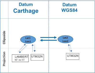
The following diagram (Figure 1)
shows how to move from one projection to another or from one Datum to another.
To change from one projection to another, first go through the geographic
coordinates (Lat/Long).

WHAT TO DO
The “Final Geological Report” is the
reference document for the coordinates of an oil well, and takes precedence
over all other documents, since it is written by the geologists and
geophysicists who implemented the well. Other documents simply transcribe the
coordinates found on this document.
To avoid errors, the coordinates of
the well should be indicated in one place only in the Final Geological Report,
and then referred to elsewhere in the document.
Projected X,Y coordinates must be
written with the Datum and projection indicated (e.g. Lambert South Tunisia
Carthage, UTM32N Carthage or UTM32N WGS84). The indication of geographic
coordinates (Lat/Long) is optional; it can help switch to another projection but
does not provide any additional information. It should only be added if you are
sure of the conversion.
Example 1 below is more specific, but Example 2 is
perfectly acceptable, clear, concise and contains all the necessary
information. You may omit the
Lat/Long but you must indicate the X,Y with their Datum and Projection. The
X's are the Eastings and the Y's are the Northings.
Example 1:
Coordinate system: Datum Carthage: Clarke 1880 IGN
Projection: UTM zone 32 North
Geographic coordinates: Latitude= 33° 17' 31.44" North
Longitude= 9° 11' 11.71" East
Projected coordinates: X=517 373.1m E
Y=3 683 406.5m N
Example 2:
Projected coordinates: UTM32N, Carthage Datum
X= 517373.1 m
Y= 3683406.5 m
WHAT NOT TO DO
It's important not to confuse
periods and commas: the decimal symbol in English is the period, and in French
the comma. Write Y= 3683406,5m in a French document and Y= 3683406.5m if the
document is in English. Writing with notations such as: Y= 3,683,406.5 m or Y=3.683.406,5 m is also confusing.
Likewise, you need to specify the
unit, which is usually meters rather than feet.
You must avoid the 2nd and 3rd decimal places, which is
useless because you are not looking for millimeter precision. To remain
accurate, it is not necessary to indicate more than two decimal places in the
seconds (1 minute of latitude equals 1 nautical mile, hence 0.01 seconds equals 0.3 m).
It is not necessary to give the subsurface coordinates in
Lat/Long because this induces errors and moreover, the working coordinates in
drilling are linear coordinates projected on the ground, i.e. X,Y.
The coordinates of the well should not be transcribed in
more than one place in the document, as this creates a risk of error. If the
coordinates change, they must be changed throughout the document, with the risk
of forgetting certain locations.
Do not attempt to convert the Carthage coordinates to
WGS84 (or vice versa) in the document as this is not the location and may cause
confusion or error during the conversion.
Not indicating the projection and the Datum used is a serious fault, as it causes about 450m positioning error between WGS84 and Carthage Datum in Tunisia.
DETAILS OF PROJECTIONS USED IN
TUNISIA
1) UTM32N projection Datum Carthage
This projection of Datum Carthage described in the
Appendix, is used by most of the work of oil companies operating in Tunisia because it is much
easier to use than the Lambert system, as it is not necessary to know whether
it is North or South Tunisia, it covers the whole territory and there is no
possible confusion between the X's which have 6 digits and the Y's which have 7
digits.
In Tunisia X, Y values in UTM32N
projection (Carthage or WGS84) vary for X from 550000m at the Algerian border
to 750000m at sea, and for Y from 3800000m in the South to 3900000m in the
North. A seven-digit Y value can therefore be quickly identified as being most
likely in UTM32N and not Lambert.
2) UTM32N projection Datum WGS84
Confusion is here! This UTM32N WGS84
projection from GPS and Google can be confused with the UTM32N Carthage
projection if the Datum is not clearly stated, resulting in a lateral offset
of around 450m. For all other Lambert, STT, Mining, NTT and KTM projections
(see below), the Carthage Datum is implied, but not here.
This Datum as well as the GPS, has
only existed since 1984, so for any document dating from before 1984, it will
certainly be the Carthage Datum.
The transformation from UTM32N WGS84
to UTM32N Carthage (and vice versa) is not a simple translation but requires
the use of a converter. In particular, the translation ΔX = -263.0 m, ΔY = +6.0
m and ΔZ = +431.0 m, often indicated with Carthage projection references, is
not valid as it concerns the centers of the two ellipsoids and not the
coordinate itself.
3) Lambert NT and ST projections (Datum Carthage)
The Lambert North Tunisia and South
Tunisia projections are Carthage Datum (although this is not mentioned, it is
implied) and are described in the Appendix. The boundary between Lambert NT and
ST is at the latitude of the town of Gafsa (34.5°N), but there is a zone of
superposition where both projections are possible without distortion. You need
to look at the assembly maps and documentation distributed by the Tunisian
Office of Topography and Cadastre (OTC) to find out whether an area is covered
in Lambert NT or ST.
The South Tunisia projection covers
latitudes 35.5°N to 31.5°N and the North Tunisia projection covers latitudes
38.5°N to 33.5°N (from longitudes 7°E to 12°E). The extreme south of Tunisia,
Borj El Khadra, is therefore not covered by the Lambert projection, nor is the
easternmost maritime area. Lambert NT or ST vary in X and Y from 100 000m to
800 000m (both 6-digit).
Tunisia's 1/50000 and 1/25000
topographic and geological maps are in Lambert NT and ST. To convert from one
of these maps to Google Earth, you need to convert the Lambert X,Y (NT or ST)
to Lat/Long Carthage, then to Lat/Long WGS84 and finally to X,Y UTM32N to WGS84
Datum (Appendix).

Figure 2: Part of the 1/50000 "Bou Ficha" topographic map giving the definition of STT coordinates. Circled at the top are X in Lambert NT projection and at the bottom YSTT in STT system (unit in km). Also circled are longitudes in centesimal Grades and Minutes of Grades of Paris origin. Lat/Long in Carthage Datum relative to Greenwich are also shown, for example: 10°25'E.
4) STT projection (Datum Carthage)
This Carthage Datum "projection"
is very important, as it is used by the Tunisian Topographic Service (STT) for
cadastral surveying. A topographer sent out into the field will report his
plans in an STT projection, which is different from Lambert or UTM32N. The STT
system, which is not a projection per se, is a Rotation/Translation of the
Lambert projection (from Datum Carthage), so that:
XSTT = YL -300000m and YSTT = -XL
+500000m for both Lambert NT and ST projections.
This STT system is very strange, as
XSTT indicates North and YSTT indicates West! It was used
by France during World War II to cover their tracks while the German army occupied Tunisia, but the
system is still widely used today.
STT coordinates for North and South
Tunisia vary in XSTT and YSTT from -250000m to
+250000m. Sometimes these STT
coordinates are indicated in kilometers on topographic and geological maps in
Lambert projection (Figure 2).
The Topographical Service uses maps
with North at the top, where XSTT are read on the ordinate axis, YSTT
on the abscissa axis, with values increasing towards the left. For example, on
the JORT (Journal Officiel de la République Tunisienne), coordinate pairs are
given (YSTT, XSTT) ordinate first, then abscissa. Figure
3 shows the areas where these values are negative or positive. In Jerba, for
example, we can expect YSTT values close to -100000m and XSTT
values close to +50000m.
However, some older cadastral maps
use local coordinates that do not correspond to either STT or Lambert.

Figure 3: Schematic map of STT coordinates for North and South Tunisia. For example, the Cap Bon and Jerba have negative YSTT values and positive XSTT values.
5) Datum Carthage but Paris origin
For old oil wells, the Datum used is
indeed Carthage, but latitudes and longitudes are given in Centesimal Grade of
Paris origin and not Greenwich, for example: Latitude: 40G 85' 70.35"N and
Longitude: 9G 70' 80.62" E, which is a position close to Kelibia with
minute and second values greater than 60. Generally, the same document also
contains X, Y in Lambert NT or ST, which are projections of Carthage Datum of Greenwich
origin and not Paris, which adds to the confusion !
To change this data from Grades
Paris to Degrees Greenwich, you need to convert the Lat/Long to decimal degrees
and then translate only the longitude from Paris to Greenwich. This system is
not uncommon, as it was used in all seismic work and oil drilling prior to
1966, as well as in water well drilling for agriculture, hydrometric stations,
etc.
In practice, first convert the
centesimal Grades, Minutes and Seconds (which vary from 1 to 100 and not from 1
to 60) into decimal Grades to the 6th decimal place (GR= Grade+MinCen/100
+SecCen/10000), then the decimal Grades into decimal Degrees (DEG=GRx360/400),
also to the 6th decimal place, then add to the longitudes only, the offset from
Paris to Greenwich, which is 2.33722917 degrees (Figure 2).
6) Mining projection (Datum Carthage)
Tunisia's mining coordinates were
modified by Decree no. 2000-946 of May 2, 2000, where their correspondence in
Lat/Long is given. This Carthage Datum system is published in the JORT (Journal
Officiel de la République Tunisienne) and used for determining the boundaries
of mining permits and concessions. All permit and concession limits calculated
prior to this date are obsolete and must be recalculated according to this new
decree.
Mining X's are even integers that
range from 92 to 720, while mining Y's are also even integers and range from 40
to 980. This is because the surface area of an elementary block is 2km x 2km.
For each X and Y, the decree gives a correspondence in Lat/Long to the Carthage
Datum (Figure 4).

Figure 4: Extract from the Tunisian mining map.
7) KTM projection (Datum Carthage)
This is a rather rare projection
used by TOTAL in the gulfs of Gabes and Hammamet and has been adopted by several
other operators.
It is a Mercator Transverse with Carthage
Datum and of Greenwich origin but uses longitude 11°E as origin and not 9°E
like the UTM Zone 32 North. The other parameters remain the same (latitude of origin:
0°N; False Easting: 500000m; False Northing: 0m and Scale factor: 0.9996).
The use of this projection is not
recommended, as it does not provide much greater accuracy and is incompatible
with work on adjacent permits.
8) NTT system (Datum Carthage)
This is a new Tunisian coordinate system recently implemented by the Tunisian administration on all projects. It concerns new topographic maps and all new work carried out by the Tunisian Topographic Service, the Mining Office, STEG, etc.
The NTT or Nouvelle Triangulation de la Tunisie system also uses the Clarke 1880 IGN ellipsoid, but it uses several projections, all close to the UTM zone 32 North projection, depending on the geographical area. There are some 277 different projections according to the area. This is referred to as a Coordinate System. The height reference is located at the "Bâb Bhar" site in Tunis, at an altitude of 7m above mean sea level. A difference of 10m can sometimes be observed between NTT and UTM32N Carthage.
Despite better accuracy, the fact that it depends on hundreds of different projections, whose parameters are the property of the OTC, makes its use exclusive and complicated.
CASE STUDIES
Ras El Besh-2
REB-2 is an offshore well in the
Gulf of Gabes drilled in 1997 by ARCO, the second well in the Ras El Bech
concession, whose location could not be traced despite an offshore magnetometry
search of the subsea wellhead. This error led to the wrong location of a
geological fault crossed by the well, and a wrong trajectory for the following
REB-3H well, which missed its main objective.
The trick to find the location of
REB-2 was to use satellite imagery: a georeferenced satellite image from the
drilling date was indeed found, showing the exact location of the platform at
the time of drilling.
Hammamet West-1
HW-1 is another offshore well,
drilled in 1967 by SEREPT in the Gulf of Hammamet. On the Final Geological Report,
there is an inconsistency (typo?) between Lat/Long Carthage and X, Y Lambert
NT, without knowing which is the correct location.
Digitizing an original seismic
position plan, and a bathymetric map both annotated in Grades origin Paris,
determined that Lambert NT coordinates were the most probable, but still with a
significant error of 300m. In 1967, positioning at sea were based on goniometry
and were themselves quite imprecise. This shows the need to know how to use the
coordinate system with Paris as origin of Longitudes.
Salloum-1
SAM-1 is an onshore well drilled in
1992 by BRITISH GAS near the port of Sfax and deviated to sea to avoid the
extra cost of offshore drilling. On the Final Geological Report, the X, Y are
given without any other indication, and the Lat/Long do not correspond to the
X,Y (assuming Datum Carthage or WGS84).
It turned out that the X,Y were in
KTM with a printing error and that there was also a Lat/Long conversion error.
All other well documents, such as logging, Mud logging reports, etc.,
transcribed the same error. We're still looking for the original location with
a field survey asking people if they remember a drilling in September 1991 !
IF YOU WANT TO DIG DEEPER
Here are a few points to help you
understand the limits of positioning, find out where errors can occur and solve
problems if the reference document is unclear:
· Factory-set
portable GPS units operate in WGS84 but can be configured in Carthage Datum.
The display changes but the data is stored in WGS84 and can be transferred to a
computer. Lateral accuracy is between 1 and 10m, altitude accuracy is less,
depending on the number of satellites the GPS can pick up at the same time.
Smartphones operate in WGS84 with a precision that can be better than that of
handheld GPS units if they are connected to the telephone network, which adds
an additional triangulation.
· In
UTM projection, Tunisia is often referred to as "Zone 32S North".
Here, S has nothing to do with South, but is a mere ordinate in the UTM zone
table (Figure 5).
· To
position a well onshore, two concrete markers need to be built: one at the
actual location of the well, and another some thirty meters away, because when
the civil engineering company comes to install the concrete Rig platform, the
first marker will be destroyed. The second marker will then serve as another reference
point.
· Petroleum
software projects such as Petrel, Kingdom, IESX, Charisma, etc. will most often
be in Carthage, whereas a GPS in standard field configuration will give indications
in WGS84. A topographer sent in the field will report coordinates in STT, a
boat will report coordinates in WGS84, and a colleague on Google Earth will also
report coordinates in WGS84. So you have to be extremely careful and convert
data to the same Datum.
· There
is a slight difference between Clarke 1880 IGN (French Institut Géographique
National), and Clarke 1880 RGS (English Royal Geographical Society), due to an
old uncertainty between the foot and the meter. The difference between the two
is of the order of a centimeter. Clarke 1880 MOD stands for MODified.
· Two
points separated by one Minute of Latitude are 1847.723m apart in the Lambert South
Tunisia projection and 1847.755m apart in the UTM32N Carthage projection, representing
a distortion of 3.3 cm for 1848m. This distortion is 5.5 cm if the two points
are separated by one Minute of Longitude (within the limits of the conversion
method). The NTT system is designed to reduce this distortion.
· A
given Lat/Long Carthage point will have different X, Y Lambert NT, Lambert ST,
UTM32N Carthage, KTM, STT or Mining coordinates. The reverse is also true, i.e.
all Lambert NT, Lambert ST, UTM32N Carthage, NTT, KTM, STT or Mining
projections of this point have the same Lat/Long (Figure 7).
· On
a mapping software, if the X,Y appear to have reasonable values but the
Lat/Long do not correspond to Tunisia, there is most probably an error in the
choice of coordinate system on the software. In case of doubt, it's best to
choose the option of loading the data without any indication of the coordinate
system, but then make sure that all X,Y values come from the same source.
· False
Northing and False Easting of projections are translations that allow you to
quickly distinguish between coordinates without making mistakes and without
having negative values. Calculating distances by subtracting negative values
can quickly lead to confusion.
· The
Tunisian-Libyan maritime border is defined in relation to the boundaries of the
Tunisian-Libyan Joint Oil Permit. The Tunisian-Algerian border, on the other
hand, is not clearly defined. At the intersection of the maritime borders
between Tunisia, Italy and Libya, there is also a few kilometers of maritime
border between Tunisia and Malta.
· The
reference for water depths on French charts is the Lowest Astronomical Tide
(LAT) whereas it's the Mean Sea Level (MSL) on English charts and English and
American websites. In Tunisia, the average is MSL = LAT + 0.90m.
· The
Fundamental Point Carthage (Figure 6), dating from 1878 and the origin of the
coordinates, is located in the middle of the entrance patio to the Carthage
Museum at the top of the Birsa hill, near the Cathedral. Latitude: 40.9464506 Grade
North, longitude: 8.8724368 Grade East of Paris, with the Astronomical Azimuth
Carthage - Bir Bou Regba: 147.82374 deg (corresponding in WGS84 to 36.85328511°
N; 10.32301687° E). The Voirol system, whose fundamental point is in Algeria,
has been completely replaced in Tunisia by the Carthage coordinate system.

Figure 5: Most of Tunisia lies in
UTM Zone 32S North. S is simply a reference and has nothing to do with the
South; in fact, the extreme South of Tunisia lies in Zone 32R North.

Figure 6: Fundamental Point Carthage located at the Carthage Archaeological Museum, used in 1876 to join Africa to Europe (via the islands of Marettimo, Pantelleria and Cap Bon). Unfortunately, no reference is visible on the base.
APPENDIX
Parameters of ellipsoids and
projections used in Tunisia
WGS84 and Carthage Ellipsoid Parameters
Datum
WGS84
Carthage
Ellipsoïde
WGS84
Clarke 1880
IGN
Demi grand axe 6378137.000
6378249.200
Excentricité
1/298.2572235630 1/293.4660213000
Projection Parameters
Projection
UTM 32N
Lambert NT
Lambert ST
Datum
Carthage ou WGS84
Carthage
Carthage
Type
Universal
Lambert
Conforme Lambert Conforme
Transverse Mercator Conique Tangentiel
Conique Tangentiel
(1 parallel)
(1 parallel)
Origine
longitudes 9.0° E
9.9°E
9.9°E
Origine
latitudes 0.0° N
36.0°N
33.3°N
False
Easting 500000 m
500000 m
500000 m
False
Northing 0 m
300000 m
300000 m
Facteur d’échelle 0.9996
0.999625544
0.999625769


Commentaires
Enregistrer un commentaire